Global Navigation Satellite Systems
GNSS or more commonly called GPS, has become a common part of all marine navigation in the modern world. Skippers have increasingly relied more on GPS over recent years. However, it does have limitations.
It relies on the use of reliable power supplies, however a failure in the electrical system would result in a loss of the GPS system. Failure to maintain a running paper chart will result in a vessel having virtually no information available on the vessels position and methods to return to safe harbour.
The GNSS signals can be easily disrupted especially in times of conflict. The nations that operate GNSS systems all reserve the right to encrypt or shut the system down for a given area at any time. In which case you will need to rely on traditional navigation means.
Please watch the above video.
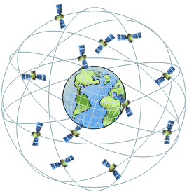
The GPS system is based on 24 satellites in 10,900 nautical mile orbits. They
give 24 hour coverage and provide a spherical position line.
4 Satellites will give you a 3 dimensional fix useful for aircraft
because the height can be calculated as well.
The GPS system consists of:-

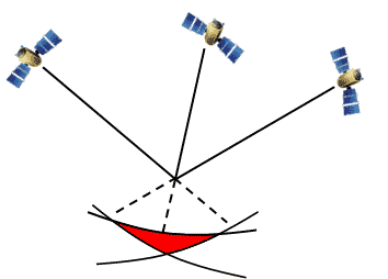
GPS creates a fix by measuring the time and distance of the receiver from the satellites
(using time as the measurement). Each satellite broadcasts a message that contains information on the satellites position, and the time it was sent. When the receiver picks up the message it can determine how far from the satellite it is creating
a spherical position line.
Due to a number of variables, and the time to calculate the position, 4 satellite fixes are
required to give certainty to our location information and to give a 3D
fix.
Speed and direction are determined by comparing the current position with previous positions, and the receivers are constantly updating and re-calculating up to several times a second, however the display that we use updates only once every few seconds.
The term GPS is now synonymous with all satellite navigation systems, however to be correct, GPS refers to the first satellite navigation system, which was developed and owned by the USA military. There are also others, most of which have equivalent levels of accuracy. All the systems vary slightly in their approach however, for 99% of users, you can not tell the difference.
Owned and operated by the People's Republic of China. With a focus on Asia, South East Asia, and the South Pacific. This network is rapidly expanding and uses the latest technology and therefore is reported to have high accuracy.
It has a unique, but potentially life saving feature. Beidou GPS allows an internal SMS feature that supports communication with rescue services.
Owned and operated by the European Union. Gallileo has been identified as the most accurate, and works excellently as a stand alone system, it also commonly supplements the GPS and BeiDou systems.
Owned and operated by the Russian Federation. Officially reported as having high accuracy, however it is also the most complicated, and the reliability is questionable.
Owned and operated by the Government of Japan, it is focused on the area of Asia and Oceania.
Accuracy increases with the number of satellites, just as with a
standard 3 point fix the accuracy increases with more fixes.
Horizontal Dilution of Precision (HDOP) is used to determine which
satellites are best to use. The smaller the number the better the
geometry. A low HDOP shows greater accuracy, the theoretical best is
1.4.
The aerial needs to be sited low down to avoid signal bounce and must
not be shielded so that the signal is interrupted.

The final accuracy is dependent on a number of factors including the quality of the device. A high quality sophisticated device can typically get within 10 metres about 95% of the time under ideal conditions, and good quality recreational marine ones are usually in the range of about 15-20 metres for 95% of the time. The GPS units on a mobile phone however can barely get an accuracy of within 100 metres 70% of the time under ideal conditions.
Highly sophisticated systems such as differential GPS, or fixed point compensation can give a much greater accuracy, but these are not suitable for yachts.
With the typical level of accuracy of GPS, a significant amount of caution needs to be considered when navigating in restricted waters.
Accuracy to waypoints is only as good as the information keyed in. A
common error is incorrect waypoints typed in and not checked.
Obtain accurate waypoints from publications but, always check them on the
chart.
Inaccuracies in GPS occur more commonly than you would realise.
As part of our courses, we include traditional navigation techniques. This is your back up if your electrical system fails, or the electronic systems get shutdown when you are relying on them.
To avoid incorrect entry of waypoints into a GNSS receiver, plot waypoints bearings and courses on your paper chart and compare it to the information given by your chart plotter or GPS.
Plotting positions on a chart helps the navigator to keep track of the
yacht's position and able to avoid hazards.
Keeping up the log book allows the navigator to go back to basics if the
GPS breaks down. The information logged can be used to plot estimated
positions.
Plot waypoints on a chart to ensure positions keyed in are correct. By
calculation GPS can give a lot more than just your position. If a
waypoint is typed in then it can work at the distance and bearing to it.
The GPS uses previous and present positions to work out SOG (Speed Over
Ground).
A display of the cross track error is quite useful because it shows how much
and in which direction you are off your proposed ground track.
GNSS only tells you where you were a few seconds ago, not exactly where you are now. So based on your speed, you may have moved quite a few metres from the position shown.
A boat moving at 10 knots will cover 5 metres every second, and if the GPS display is only updated every 5 seconds, then that means you can be 25 metres away from the position the GPS is telling you, and this is not taking into account the possible accuracy which can mean you may be more than 40 metres away from where the display is indicating that you are.
